Transportation Infrastructure
Create a fully integrated virtual 3D model of transportation infrastructure
When it comes to construction and design jobs, efficient and accurate data collection, is vital to the overall project success.
LiDAR technology makes the evaluation of existing roadway conditions simple, efficient, and reliable, giving you and your crew more time to focus on the job at hand. LiDAR scanning allows you to track the surrounding environment with minimal traffic disruption or risk to survey personnel.
Our highly versatile scanning capabilities means we are able to provide scans along sidewalks, bike lanes, residential, collector, arterial, or highway segments,
Mounted to our truck or UTV, LiDAR scanning produces dense and highly accurate point clouds to detail the transportation environment as seen by commuter, commercial, pedestrian, and cyclist traffic.
Whether intended for the preservation of the current roadway environment or in preparation for future maintenance or engineering design, the detail collected with LiDAR scanning is ideal for capturing as-built conditions and evaluating roadway, sidewalk, or bike lane conditions.
POTENTIAL APPLICATIONS
Existing Condition Assessment
The detail provided by Nektar 3D’s Mobile Mapping platform is ideal for condition assessments for construction or consulting projects. Providing millimeter accuracy of the surrounding assets and environment, these details can be quickly quantified into 3D computer-aided design (CAD) models of the existing conditions.
By transforming the detailed LiDAR scan into the design-friendly CAD format, Nektar 3D Mobile Mapping helps contractors and consultants to establish an improved understanding of existing conditions, which is vital to the design of future infrastructure elements at the location.
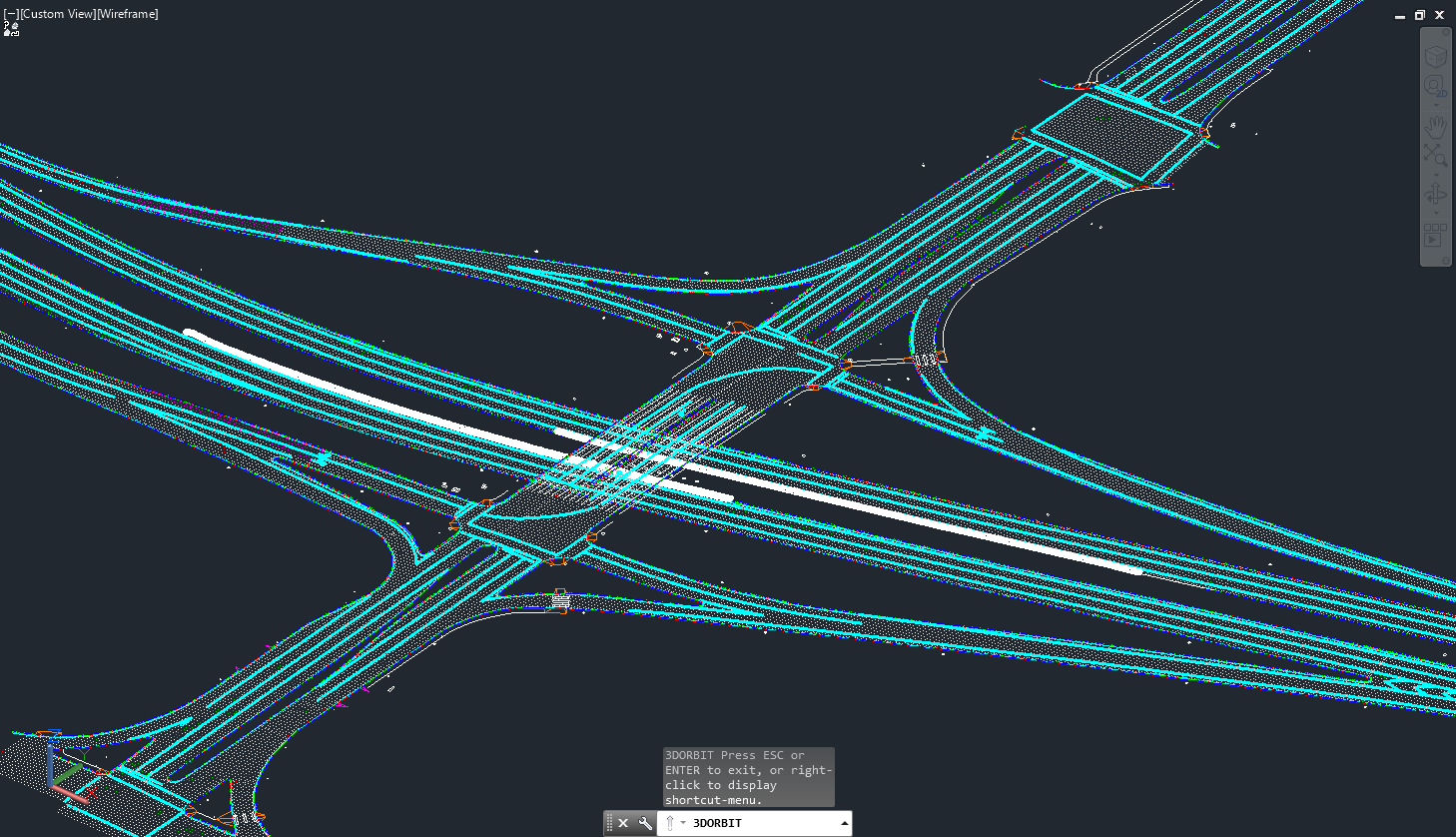
Project-wide Topographic Survey
Save time by conducting a complete topographic survey from a single mobile LiDAR pass. Extrapolated over multiple kilometers of roadway, Nektar 3D Mobile Mapping’s LiDAR scans can be used to produce 3D CAD documentation of all existing infrastructure surrounding a project. These CAD drawings could then be used to plan and redesign this interchange. Some of the extracted infrastructure features included:
Lane markings (dashed, solid, chevrons, arrows, stop-lines and crosswalks)
Curbs (top, bottom, and back)
Edge of pavement
Edge of concrete walkway
Roadway survey points at chosen grid size
Pararamps and Driveways
Guardrail/high-tension cable barrier alignment and post locations
Underside of bridge girders and supporting bridge columns
Surface utilities (electrical poles and pedestals)